Well friends, Spring has arrived in the Northern Hemisphere, and for many of us that means spending more time outside hiking, camping, boating, swimming, and for some of us, Gardening. For gardeners, this is an exciting, if somewhat challenging time. Getting the garden set up, deciding what to grow, prepping soil, planning, and yes, Mapping out the garden.
I’m speaking here mostly of amateur vegetable gardens, as that is what I enjoy doing most. Besides giving me more time outside and some moderate exercise, I enjoy the relaxation of working with nature and pretending to be a gentleman farmer of old, in addition having healthy and fresh vegetables from my own back yard.
As with many endeavors, planning is a key to success. That said, I have often approached my garden with a haphazard “throw it together” approach. While this seems fun at the time, I find I end up wasting time and ending up with wasted space and a harvest less abundant and healthy that I’d like. So, I’ve decided to do what most successful gardeners do, and map out my garden, make a plan, and keep track of what happens. While I’ve helped others with garden mapping, I have yet to apply my skills to my own garden. I’ll let you know how it goes, and at the same time share some tools, techniques, and approaches to use GPS and GIS mapping in your gardening efforts.
In my climate in Seattle, I can often garden your round, IF I plan correctly. Stay tuned for more…
FYI, take a look at this great gardening website I found: gardentherapy.ca
Here is a simple and attractive example of a hand drawn map from this site

This is a cute, creative, and plenty useful calendar for the garden. However, lacking the creative ability (or legible handwriting), I’m taking a different approach.
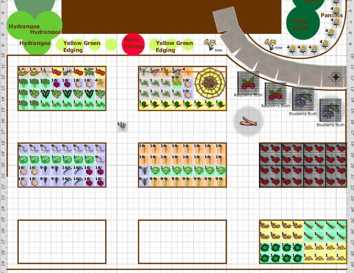
As a GIS Specialist, I’ve decided to take control of my Gardening information using a computer mapping approach. Geographic Information Systems (GIS) combines the flexibility of digital mapping, the data management and manipulation of databases, and ease of combining information, photos, measurements, and calculations to provide a powerful Garden Management tool. Lots of folks have done this, and there are some useful tools available on the Web; but I’m going to use the tools I have to build a robust, yet easy to use GIS based tool to help me manage my garden this year and into the future. The specifics will be laid out in a future blog, coming soon. Suffice it to say it will include a precise map of my garden with measurements, plant, soil science, and other information, combined with pictures, etc. Stay tuned, and please feel free to send comments, questions, and suggestions to me at: SynthosLLC@gmail.com.
Below are a few garden pics from April 11, 2021. Just getting started here in Seattle. Stay tuned!


