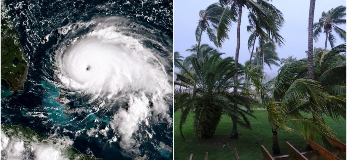
Leading up to this Labor Day holiday weekend, there has been much discussion and concern over the location of landfall of Hurricane Dorian. Early models had predicted it might slam into the east coast of Florida, causing severe damage from high winds and flooding of various forms. The most recent NOAA National Hurricane Center prediction is a bit uncertain as to the exact location and time of landfall on the US east coast. However, the Bahamas are being hit now (2:PM Eastern). The storm packs 185 MPH winds at its center. The Bahamas don’t have much elevation, so the damage from storm surge and flooding could be severe.

Whereever Dorian goes however, flooding potential is very high for most of Eastern Florida, and ultimately even Georgia, the Carolina, and possibly points north. While it is too late to plan for Dorian, this event raises yet again the issue of smart planning for future flooding events. With all the accurate data sources and excellent GIS tools available now, people can do much better planning and take action to better protect their homes, businesses, and properties.
Predicting and Mapping Flood Risk
“But how do we know what to do and where to do it?” you ask. Well, for many years FEMA the Federal Emergency Management Agency has maintained a series of flood risk maps for much of the United States. While the science behind the FEMA maps is good, they are almost always well out of date, at a geographic scale that is too course for property level decision making, and lack consideration of several important factors that need to be considered in assessing flood risk. Since FEMA maps were initiated, we have much more data and a far greater understanding of factors such as storm surge, global warming, and sea level rise. For property owners, businesses, and local governments to make important improvements to their flooding preparedness, they need much more detailed and especially more timely information based on the best science available. FEMA maps just don’t do it for modern flood risk assessment.
If you are a GIS user, there are some tools to help you in this area. The NOAA National Hurricane Center has GIS data available for download, as do many local city, county, and state governments. With knowledge of the science of flood prediction, good GIS training and experience, and timely data; one can piece together some good hazard maps. Still, the time and resources needed, the search for data needed at a local level, and the lack of integrated models, etc., make the production of usable GIS based Flood risk products nearly impossible, at least when faced with time sensitive situations, and a variety of data sources and local geographies.
A More Integrated and Elegant Solution is Needed
Thankfully, there is a solution out there. One of our business partners, Coastal Risk Consulting, LLC is a leader in the production of top quality, scientifically robust, affordable flood risk products. Their reports far exceed FEMA flood maps and all other flood risk products out there. My company, Synthos, LLC recommends Coastal Risk to all my clients and contacts dealing with flood risk issues. You can learn more about Coastal Risk Consulting and their products at: www.floodscores.com.
Key strengths of their reports are:
-A broad base of verified data sources is used.
-Robust Scientific procedures.
-GIS based analysis and mapping.
-Include riparian, coastal, sea level rise, hurricane, and rainfall risk factors.
-Property level assessments for both homeowners and businesses.
-VERY cost effective. Reports start at $49.
-Fast and responsive. Most reports can be delivered within an hour or two of initiation.

Contact us for more information BEFORE you face a severe flooding situation!
We can answer all your questions, and provide you with a sample report to look over.
We at Synthos, LLC are representatives for Coastal Risk Consulting on the West Coast, specializing in Federal Government agencies. Contact me, Tom Simon, directly at: SynthosLLC@gmail.com, www.synthosllc.com, or call me at 206-406-5246.
You can also go to www.floodscores.com. Tell them Tom Simon sent you! You will be amazed at how much you can learn about your property’s flood risk, and potential mitigation measures you might take.