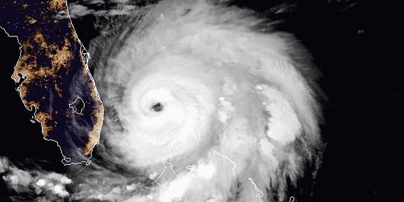
Well, it’s Hurricane Season, and as usual, all eyes are on the Caribbean, Gulf of Mexico, and the southeastern coast of the US. This week it is Hurricane Dorian, a large powerful storm that is providing some frustration to professional and amateur storm predictors and mappers delight, as well as a great deal of damage to the islands of the Bahamas. We wish all the people there safety and a speedy recovery from the damage.
We are all familiar with the cool graphics and informative maps we see on TV and the Internet. (See samples below). These are created by professionals in the GIS and Graphic arts fields, with large budgets, etc. They seem to be out of reach of the capabilities of the average GIS user, or even just the interested weather nerd.


However, you can do it too!
Today there are many tools available for the non-professional to use in mapping, tracking and analyzing extreme weather events. Free, or almost free software such as ArcGIS Home, QGIS, and Google Earth provide excellent platforms for even novice users to track and analyze weather events at home. As for data, there is tons of it available.
Most prominent of the data sources for weather related issues is the National Weather Service.
NWS maintains a large amount of data and tools available for free download and use by the public; including storm tracks, wind field data, basemaps and a plethora of other datasets. You can find Hurricane related data at: https://www.nhc.noaa.gov/gis/. Much of the data is already packaged into .KMZ files, which can be automatically opened in Google Earth, just by downloading and double clicking on the file, assuming you have Google Earth installed.

For the weather enthusiast, this is a great place to start, and takes you several steps beyond just watching the evening news or CNN “Creaking News!” Such uses can enable one to do everything from planning and advising friends and family on travel, to evaluating effects on corporate assets in near real time (and more precise detail), to just keeping a personal record of events in a GIS type, interactive form, and producing maps (for you fellow weather nerds out there!).
We here at Synthos can help you if you need a little assistance. If you are a company wishing to set up a GIS system, perhaps including weather tracking; we can help you there too. As Synthos President, I am a Bona Fide Weather Nerd myself, and I love helping others use the magic of GIS.
Call me any time: 206-406-5246, or E-mail at: SynthosLLC@gmail.com.
Best regards, Tom Simon.